Description
Introduction
A landlocked country Nepal is in Southern Asia, between the Tibet autonomous region of China and India. It contains 8 of the world’s 10 highest peaks, including Mount Everest – the world’s tallest –bordered with Tibet, and Lumbini, the birth place of Gautama Buddha, the founder of Buddhism. A monarchy for hundreds of years, Nepal was declared a republic in June 2008.A very diverse geography, rising from less than 100 meters (328 ft) elevation in the tropical Terai, the northern rim of the Gangetic Plain, beyond the perpetual snow line to some 90 peaks over 7,000 meters (22,966 ft) including Earth’s highest Mount Everest or Sagarmatha at 8,848m (29,029 ft). A landlocked country Nepal is in Southern Asia, between the Tibet autonomous region of China and India. It contains 8 of the world’s 10 highest peaks, including Mount Everest – the world’s tallest –bordered with Tibet, and Lumbini, the birth place of Gautama Buddha, the founder of Buddhism. A monarchy for hundreds of years, Nepal was declared a republic in June 2008.
A very diverse geography, rising from less than 100 meters (328 ft) elevation in the tropical Terai, the northern rim of the Gangetic Plain, beyond the perpetual snow line to some 90 peaks over 7,000 meters (22,966 ft) including Earth’s highest Mount Everest or Sagarmatha at 8,848m (29,029 ft). Prithvi Narayan must have been a charismatic figure, for he recruited, equipped and trained a formidable army and persuaded his subjects to underwrite all this from his ascension until his death in 1775. Through conquest and treaty, he consolidated several Chaubisi kingdoms. As his domain expanded, Khaskura became known as Gorkhali, i.e. the language of the Gorkha kingdom. Then he moved east into the next river basin, the Bagmati which drains the Kathmandu Valley that held three small urban kingdoms. Like the Rapti, the Bagmati rises somewhat south of the Himalaya. Unlike the Rapti basin, this valley had once held a large lake and the remaining alluvial soil was exceptionally fertile. Between the agricultural abundance, local crafts, and extensive trade with Tibet, the cities were prosperous. Prithvi Narayan encircled the valley, cutting off trade and restricting ordinary activities, even farming and getting water. With a combination of stealth, brutality and intimidation he prevailed and deposed the local kings in 1769, making Kathmandu his new capital. This was the high point of Prithvi Narayan’s career; however he continued consolidating the Kathmandu Valley with the Chaubisi and Baisi federations to the west until his death in 1775. Gorkhali was re-dubbed Nepali as ‘Nepal’ came to mean not only the urbanized Kathmandu Valley, but all lands ruled by the Shahs.Nepal is also one of the richest countries in the world in terms of bio-diversity due to its unique geographical position and variation in altitude. The elevation of the country ranges from 60 meters above sea level to the highest point on earth, Mt. Everest at 8,848 meters, all within a distance of 150 kilometers resulting in climatic conditions from sub-tropical to Arctic.
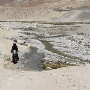
LOWER MUSTANG
Exploring the terrain of a land is best done on a motorcycle and Nepal is a country with innumerable types of terrain. Nepal is also where the ice – cold, mighty Himalayas meet the lush green tropical region of the Terai plains. For the past few years Nepal has become a popular destination for motorcyclist around the world as it offers views of the magnificent Himalayas, colorful and vibrant cultures, ancient temples and monasteries, jungle safari in search of the elusive tiger and more…
This ride is one of the ultimate rides in the rain shadow part of the wind-swept desert landscape of the Himalayas with views of implausible gorges, high passes and enormous vistas passing through authentic Tibetan villages, barren ridges, eroded cliffs and Moraine valleys. Its landscape is unrivaled for it has a stupendous wilderness, pristine scenery, snowcapped peaks, spectacular monasteries and caves.
TIBET- “Roof of the World”
A sacred land of myths and mysteries inhabited by the ever smiling people, has not only exerted a magnetic pull upon travelers for centuries but also spies, missionaries, scholars, geographers, mystics, soldiers and cranks, etc. Yet, only a few intrepid, serious and determined have been able to make it.
Tibet was opened to tourism in 1985. Before this, it avoided influence from the West and this country developed its unique culture and religion independently. Since Tibet was governed by the spiritual leaders, monasteries and religious institutions were the backbone of power so the importance and prestige were shown by the size and magnificent architecture of these buildings. Tibetan Buddhism contains many elements of their older religion,” Bon Po” which worshipped the sky, moon, sun, fire, soil and even evil spirits and this is why a monastery such as Tashilhunpo contains thousands of unique statues, paintings (thangka), religious and historical books. The Monasteries are crowded by pilgrims who often travel long distances to fulfill their vows and wishes and their emotions show that religion still holds a very important place in their daily lives.
Full name: Tibet Autonomous Region of China
Area: 1.2 m. sq. km
Population: 3 million
In Exile: 300,000
Capital city: Lhasa (Population 200,000)
People: Tibetan & Chinese
Language: Tibeto Burmese, Tibetan and Chinese
Religion: 90% Buddhist, 1% Muslim, 3% bon, 6% others
Government: Occupied by China in 1949/1950
Currency: Yuan (Y 6.87 = US$ 1.00)
Geography: Tibet has border with India, Nepal, Sikkim, Bhutan and Burma
Climate: Spring (May to June) – Best weather condition, May to Mid-September Winter – (October to April)
What to wear: Light weight clothing is recommended for May to June, Warm garments are required from September to April. An umbrella or a raincoat is a must for the summer season.
Voltage: Standard voltage only 220 volts.
The Tibetan landscape changes from lush green to rugged and barren and harsh and cold, yet, magnificent and awe inspiring at the same time. The many serene and sacred lakes you come across makes you truly understand why they say it’s the “water tank of central Asia”.
ITINERARY
Day 01: Welcome to Kathmandu (1370m)
Upon arrival met by representative at the airport and later board the waiting vehicle and drive to Hotel.
15:00 Hrs: Met by the Road captain and introduction to the Royal Enfield Motorcycles. There will be a short briefing about the safety and the proper speed to ride on the roads of Nepal followed by a question and answer session.
18:00 Hrs: Board the waiting vehicle and proceed for a welcome dinner at typical Nepali Restaurant.
After dinner, board the waiting vehicle and drive to Hotel.
Overnight at Hotel
Day 02: Ride Kathmandu to Bandipur (1030m/4.45Hrs/150km)
After breakfast, we negotiate the traffic out of the Kathmandu city and ride out of the valley at the cross section of the ring road at Kalanki, continue south towards check post at Nagdhunga, just past Thankot.
From here, the road ascends twisting and turning as we negotiate the traffic to Naubise, 26 kilometer marker (about 17 kilometers from Nagdhunga). Then the road becomes much wider and smoother. We continue riding and arrive at Mugling, the junction where the highway bifurcates, south to Chitwan and west to Pokhara. Head west crossing the bridge and follow the Marshyangdi River for about 25 kilometers to Dumre town. Continue for another ½ kilometer and then take the left turn to Bandipur Township.
This 8 kilometer ride is a pleasant one as we continue to ascend on a winding path. Upon arrival check into the hotel and rest of the afternoon is free to relax and explore around the Bandipur village.
Bandipur is a picturesque town nestled in the himalayan foothills of Nepal, a land as famous for its natural beauty as for the hospitality of its people. Bandipur has been described as a natural view tower as one can view the spectacular panorama of the entire Annapurna range including the peaks of Dhaulagiri, Manaslu and Langtang from here. Apart from the stunning views of the Himalaya and the Marsyangdi Valley, a visit to the town is an opportunity to get a close look at Newar cultural life.
Overnight at Hotel
Day 03: Ride from Bandipur to Tatopani (6.14Hrs/175km/1190m)
Firstly, descend to the main highway near Dumre and then head west following the Marshyangdi River for a while and then slowly ascend through terraced agricultural lands and small road side villages. At the outskirts of Pokhara, we are greeted with views of the Annapurna Mountain range including the famous Fish Tail Mountain.
Pokhara stands at 827 meters above sea level and is an ideal vacationer’s paradise. With its crystal clear lakes, magnificent views of the Annapurna Mountain Range and its bustling but quaint lake side bazaar, it is a major tourist attraction. From here most of the treks starts for the western region and is a haven for people who wants to relax in this serene mountain beauty. The Annapurna mountain range is impressive by any standard and looming ahead to take the center stage is Machapucchre or “Fish Tail Mountain”, which gets its name from the shape of its summit and flanking it from either side are the great mountains of the range including Annapurna I (8091 m), the first 8000 m peak to be scaled in 1950. The range continues to meet the Lamjung Himal in the east while to its west looms the massive dome of Dhaulagiri (8161 m).
Leave Pokhara and ride towards Beni (approx. 83 Kilometers) on the Baglung Highway. This section of the ride provides fantastic mountain vistas, picturesque terraced farmlands and an opportunity to walk on one of Nepal’s famous suspension bridges. At Mal Dhunga, leave the main highway by taking the right trail and follow a dusty graveled path all the way to Beni, the district headquarters of Myagdi District in Dhaulagiri Zone. It is located on the confluence of Kali Ghandaki and Myagdi rivers at an altitude of 799 meters and is a bustling town lined with stores, restaurants, hotels and various government offices.
From here, the road is unpaved and dusty with potholes in several places. Unpaved, graveled rough road poses a real challenge for riders and makes it more difficult with the occasional river crossings.
Ascend gradually through the Kali Gandaki gorge, the deepest gorge in the world. There is a continuous change in the topography with every twist and turn until our arrival at Tatopani.
Tato” means ‘hot’ and “Pani” means ‘water’, a name earned courtesy of the hot springs and is a popular place for trekker’s to relax and dip their weary bodies in the natural hot springs.
Upon arrival at Tatopani, check into Hotel
Overnight at Hotel
Day 04: Ride from Tatopani to Muktinath (5Hrs/64km/3800m)
After Breakfast, set out on the trail by following the Kali Gandaki River and passing the Thakali and Magar Villages to Dana (4750 ft. / 1446 m.) famous for its beautiful cascading waterfall. Steeply ascend to Ghasa (6600 ft./ 2012m) and continue the ride on a dusty and one of the difficult section of the road towards Jomsom via the Thakali villages of Tukuche and Kalopani. Enroute, there are fantastic views of the Mt. Dhaulagiri (8167 m), Tukuche (6920m), and Nilgiri (7061m).As we pass between the Dhaulagiri and the Annapurna mountain range, a dramatic change in vegetation is witnessed from green forests, to dry arid desert. It takes gradual acclimatizing with the surrounding. The Thakali’s are the dominant tribe of the valley, related to the Gurung and Magars of the southern slopes.
As soon as we pass Ghasa we will come to a place known as Dhaiku where we have to cross the bridge. After riding approximately for 10 kilometers via Lete we will come to our today’s destination Kalapani. Kalapani is scaled to be at 2530 meters. One can enjoy a very beautiful view of Mt. Nilgiri and Mt. Tukuche
This day’s journey is a tough one but the scenic views of the rugged landscape, beautiful cascading waterfalls, orange and apple orchards, scattered roadside villages, ancient Buddhist monasteries all make it ‘One Hell of a Ride”.
Jomsom (2700 m) is more correctly known as Dzongsam or New Fort. It spreads over both the banks of the Kali Ghandaki. The towering peaks of Dhaulagiri and Nilgiri form an attractive backdrop. Being the district headquarters, it is primarily an administrative and commercial center with government officials and merchants rubbing shoulders with the local inhabitants of the region, known as the Thakalis. Jomsom is the Administrative center of the Mustang region and the gateway to the Annapurna region. A land of mystique, the rugged peaks of the Annapurna, Nilgiri and Dhaulagari gaze down in their awesome splendor at weathered landscapes that contrast with the deep river ravines over noisy riverbeds. Jomsom is a mixture of hard work, social frivolity tempered by culture founded on deep religious traditions. It has the only airport that operates daily scheduled flights to Pokhara in the early mornings before the winds build up.
From here continue ride passing through the village, past the High Altitude Mountain Warfare School of the Royal Nepal Army and through several restaurants, bhattis and a hospital. We pass through the old Jomsom village which boasts of several lodges, restaurants school and government offices. At the end of the village the valley opens wide, take the left side of the trail just after crossing the three ruined chorten and continue on the east bank of the Kali Ghandaki River. After about 20 minutes, arrive at Ekklaibhatti a small village with few lodges. There are two trails here. The left will lead to Kagbeni while the right one leads to Muktinath. We take the right trail and continue to ascend slowly to the settlement of Jharkot, which has a fort “Kot”.
Kagbeni at an altitude of 2800m is a fascinating medieval village with closely packed mud brick houses, dark alleys and imposing chortens lies along the Around Annapurna Trekking route and is the gateway to Upper Mustang. The village stands in a little green oasis dominated by its red monastery. Though the village has a very medieval look, it can provide all the modern amenities that a traveler requires. This is the only village after Jomsom where there is an internet facility for communication with the outside world. This village also boasts of a Monastery. The monks here are of the yellow hat or the Gelukpa Sect and have only recently opened their monastery to visitors with a legitimate entrance fee of Rs 100, which they collect for the maintenance of their school.
From here, another 15 minutes of an ascent on the desert plateau with fantastic views of the Himalayan high desert landscape which finally brings us to Muktinath.
Upon arrival at Muktinath, check into Hotel.
Late PM: Visit Muktinath Temple
The Muktinath Temple is a sacred place both for Hindus and Buddhists and is located at an altitude of 3,710 meters at the foot of the Thorong La (5416 m Pass), Mustang district, Nepal. The site is close to the village of Ranipauwa, which sometimes mistakenly is called Muktinath as well.
The Hindus call this sacred place MuktiKshetra, which literally means “Place of Salvation”. This temple is considered to be the 105thamong the available 108 Divya Desam. The ancient name of this place, before the Buddhist origin was known as Thiru Saligram.
In Muktinath-Chumig Gyatsa all the elements are represented and for this and reasons unseen, yogis from both religions do their meditation at Muktinath. For Tibetan Buddhists, Muktinath (Chumig Gyatsa) is a place of Dakinis (goddess known as Sky Dancers). It is of great importance for Buddhists as Chumig Gyatsa is one of the 24 Tantric places.
For Hindus, beside the natural fire representing Brahman and the holy waters, the central meaning of the Muktinath area is veneration of the god Vishnu in the form of ammonites (shilas) called Salagrama – Shilas.
There are many stories which tell of Vishnu turning into stone and all of them are closely connected to the holy Kali Ghandaki River. According to contemporary geologists, the Salagrama – silas (found at the banks and river bed of the holy river Kali Ghandaki) are fossils of a prehistoric insect. This insect is mentioned in the Bhavisya Purana. Therein, Tulasi, the sacred plant so dear to Vishnu, cursed Vishnu to become a stone during one act of their eternal lila. Vishnu said, “To fulfill your curse, I will become a stone (Salagrama-sila) and will always live on the banks of the Ghandaki River. The millions of Vajrakita worms that live at that place will adorn those stones with the signs of my chakra by carving them with their sharp teeth”.
After the sightseeing tour of Muktinath Temple descend down to the Ranipauwa (Main Bazaar of Muktinath).
Overnight at Hotel
Day 05: Ride back from Muktinath to Tatopani (5Hrs/64km/1190m)
After Breakfast, ride out of Muktinath towards Tatopani.
(Note: The Kaligandaki Valley becomes increasingly windy during the day as the winds blows south to north and makes it difficult for travelers)
After spending some time at Kagbeni continue ride to Jomsom (approx. 11 Km) but we continue further 25 kilometers, about 1 ½ hour slow ride to Kalopani via Marpha Village. From Here we ride through Marpha village at an elevation of 2670 meters. Marpha is famous for its apple orchards and apple products. This large Thakali village exhibits the typical Thak Khola architecture of flat roofs and narrow paved alleys and passageways. It also has a monastery.
After ride another 1 to 1 ½ hour to Kalopani then, we stop lunch at Kalopani. After lunch continue our ride to Tatopani
PM: Visit Hot Spring at Tatopani.
Overnight at Hotel
Day 06: Ride Tatopani to Pokhara via Beni (810m/124kms/5hrs)
After breakfast retrace the route till Pokhara Lunch at Beni / Nayapul.
Upon arrival at Pokhara check in to the hotel and rest of the day is free to relax and explore around the lake Bazaar.
Overnight at Hotel
Day 07: Free day in Pokhara
Free day to relax and explore around the lake bazaar for the souvenir shopping or sightseeing tour around city. Adventure activities like paragliding, bungee, ultra-light; zip flyer etc. can be performed in Pokhara.
Overnight at the Hotel
Day 08: Ride from Pokhara to Nuwakot (6Hrs/182.2km/1022m)
After breakfast met by the road captain at the hotel lobby and later ride 196Kms to Nuwakot. This day’s ride is mostly on the Pokhara/Kathmandu highway and we ride 90Kms to arrive at Mugling. From Mugling head north towards Kathmandu and arrive at Galchi (55Kms), a non-descript roadside village located at the cross section and the road on the right follows the Trishuli River into the Trishuli Bazaar.
The beauty of the area is not easily forgotten. The rolling hills, the Trishuli River, ethnic villages, suspension bridges all make it a very interesting ride. A little after Bahun Besi, the small village of Kosh kade is located on the other side of the suspension bridge which is the venue for annual Bullfighting festival that takes place during Maghe Sakranti festival in January.
In an about 45 mins of scenic ride arrive at the suspension bridge and enter a busy and populated settlement of Devi Ghat. Then continue for another kilometer to meet up with the main road from Trishuli Bazaar. From here, the road is black topped and riding along a path lined with pine trees for another 10 kilometers brings us to the famous Trishuli Bazaar.
The name, Nuwakot, is made up of two words ‘nawa’ and ‘kort’. Nawa means nine in Nepali and ‘kort’ means sacred religious site at the top of the hill. The district accordingly has 9 nine hills over which various deities are said to dwell thus overseeing and protecting Nuwakot. This has led to Nuwakot often being called “City of nine hills”. The place has carried a long history of the entire country Nepal.
Upon arrival at Nuwakot check into the hotel
Overnight at the Nuwakot Famous Farm, Nuwakot
Day 09: Ride from Nuwakot to Timure (4Hrs/77km/1450m)
After early breakfast at the farm we will be heading toward to Timure.
After lunch head north and continue ride to Dhunche & Syabrubesi. From here steep descend on a winding and snaky trail till Syabrubesi.
Note: There are many military and Police check posts and everyone is required to show permits and luggage searched. Usually they are looking for animal and flowers that people take from the National park.
Upon arrival at Syabrubesi, Ride another 11 kms to Timure.
Overnight at the Lodge
Day 10: Ride Timure to Kyirong Town (2700m/40kms/3hrs)
After breakfast ride approx. 16 Km to Kyirong – Nepal / Tibet border, the last border town, complete Nepali Immigration formalities and cross the friendship bridge. Complete Chinese Immigration and met by guide and Rider from Tibet. Proceed for China Custom clearance for the motorcycles and after completion, load up the gear on the waiting Landcruiser / Mini Truck and ride for another 24 kilometer to Kyirong town.
Kyirong, one of the frontier counties of Tibet Autonomous Region, lies in the southwest of Tibet and the southwest of Xigaze prefecture, covering 9,126 square kilometers with a population of 10 thousand. kyirong means in Tibetan happy village. kyirong Town is one of the important towns in Kyirong County, with a sea level of 2,700 meters. Pagba Monastery, Chagar Monastery and Qiangzhen Monastery are main monasteries of Kyirong and kyirong Jiangcun Nature Reserve is the famous beauty spot.
Up to 1960 one of the main trade routes between Nepal and Tibet passed through this region. Easily accessible from Nepal, it was used several times as an entrance gate for military actions from the site of Nepal against Tibet.
Upon arrival, check in to the Hotel.
Rest of the day is free to relax or explore around the town to acclimatize.
Overnight at the Hotel Kyirong Phuntsok Rabsel or similar
Day 11: Ride Kyirong to Tingri (4348m/ 265 kms/6hrs)
Today is a most enjoyable day’s ride all the way to Tingri as we head eastwards with the sun in our face.
It’s a scenic ride crossing over passes (Guntung La at 5200 m), the famous Paikut Tso (lake) and then the trail wends upwards to the North East route sprawling over and traditional picturesque villages. This scenically rewarding ride provides plenty of opportunities for photography. On this day’s ride over the sandy and rocky landscape of Tibet, other sites like lake, nomads chasing hundreds of yaks and sheep, keep you busy. Look out for the Kiang “Wild Ass” that roam freely in big herds, the Tibetan Antelope and the Marmots.
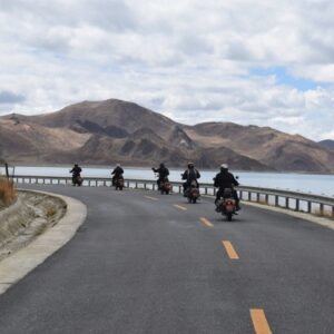
As we ascend to the top to meet up with the main Friendship Highway, is a direct route from Lhasa to Kathmandu, where the mountains are dwarfed by the vastness of the Tibetan plateau.
Descend for about 50 kilometers to the settlement of Tingri, a line of houses (hotels,
restaurants and shops) on either side of the street.
Upon arrival at Tingri, we check into the hotel. Tingri used to be an important trading post where Sherpas from Nepal exchanged rice, grain and iron for Tibetan wool, livestock and salt. It gives its name to the broad upland basin more than 4,500 meters high that is known as the Tingri plain. Shallow, fast-flowing rivers of melted snow water make its grassy meadowland ideal for grazing by livestock.
Overnight at the Hotel
Day 12: Ride Tingri to Shegar National Park Check post to Tashi Dzom and Electric Bus to Rongbuk (EBC (5100m/172kms/5hrs)
From Tingri set out for Shegar an easy 68 kilometers stretches. However, we take a right turn into the Chomolungma National Park Entrance gate 4 kilometers before arriving Shegar.
We purchase the permits and National Park entrance tickets and once again drive for about 2 kilometers to arrive at another check post which is operated by the Quomolongma National Park and is the gateway into the Quomolongma (Everest National Park). Here it is mandatory to present all the National Park entry permits for clients as well as the motorbikes.
After receiving clearance, ascend on a zig zag trail to Gyawla Pass at (5200 m) which is strewed with prayer flags. A few entrepreneurs set up shop selling souvenirs, prayer flags and tea / cold drinks / can juice. Pilgrims purchase these prayer flags and after writing the names of the family members stretch them along the hillsides. It is believed that as the wind flutters the flags, their prayers reach heaven. Weather permitting; there are great views of Mt. Makalu, Mt, Everest (Quomolongma), Cho Oyu and others.
After a stop to view the Himalayas, descend once again zig zagging our way on 100 switchbacks all the way to the valley floor and then ride towards the settlement of Tashi Dzom.
We park our Motorbikes in the parking lot and take our essentials for the 1 nights stay Rongbuk and load them on the bus.
As we wait for the departure, we enjoy lunch at one of the restaurants.
After lunch, board the waiting electric bus for the 45 kilometer drive to Rongbuk following the Drakar Chu (River) and making slow but steady ascent. After a while, the views of Mt. Everest looms over us and as we a turn bend, we suddenly arrive at Rongbuk and the Lodges. In the distance, towering above everything else is the magnificent and awe inspiring view of Mt. Everest – Mother of the Earth at 8848 m. Following a close second is the Rongbuk Monastery with its Massive Chorten and ancient monastery. Upon arrival, check into the Rongbuk Monastery Guest House.
In the afternoon, take a walk by following the dirt road south and the Dzakar Chu (river), now much reduced in volume, is on your right. Soon the valley broadens and the road leaves the river to continue its ascent on the other side, swerving to avoid a rockslide. At the base of the slide is chorten; at its top are the ruins of the Samdrupo Nunnery (a small chapel has been rebuilt). The tented settlement of Dza Rongphu was relocated from the Everest Base Camp, which was situated just beyond some moraine hills a mere 4 kilometers away It is here that the new Everest Base Camp Marker has bed erected. Tourists and vehicles are prohibited to go further than here.
After being one with the mountain, spend some time at the tented city for a cup of tea/ noodle soup or shop for souvenirs or even send a post card from the mobile post office which is considered to be the highest post office in the world at 5200m.
Later, walk back to Rongbuk and visit the ancient monastery.
Rongbuk Monastery was established around the early 20th Century and is considered to be the highest monastery in the world. It is governed under the Nyingmapa Sect (one of the 4 major sects of Buddhism). The Rongbuk Valley is known as the “sanctuary of the birds” and there is a strict ban on killing any animal in the area. There are herds of Blue sheep that dot the hillside as well as the road side and sometimes also come down to the monastery.
The monastery was razed in the 1960s by a fire and rebuilding took place at Rongbuk Monastery in the late 1980s and early 1990. The monastery has now been resurrected, along with the stupa that figures prominently in tourist photography of the scene. In Rongbuk Monastery, some of the murals are superb. The monastery and its large chorten make a great photograph with Mount Everest thrusting its head skyward in the background.
EVE : Enjoy the sunset over Mt. Everest
Overnight at the Rongbuk Monastery Guest House.
Day 13: Drive Rongbuk to Tashi Dzom on Electric bus and then Ride to Thingri to Kyirong via Paikut Tso (2700m/356kms/7hrs)
Early morning wake up to see the sunrise over Mt. Everest. It is quite spectacular.
After breakfast, we board the Electric bus and drive to Dza Rongphu parking lot. After loading our belongings into backup vehicle, we enjoy a short tea break before setting out on our long day’s ride.
The 60 odd kilometers are now paved and so riding is easy and we make fast progress to arrive at the high Tibetan plateau with good views of Cho Oyu (8201 m) and enter the settlement of Tingri for an early lunch or pick up purchase to enjoy a picnic lunch alter in the day around the close proximity of the Lake Paikut Tso.
Set out from Thingri on the highest plateau of the world with typical view of the Tibetan landscape offering sheer feeling of standing on the roof of the world. The Lalung La (5050m) and Thong La (5128 m) are the highest passes here and weather permitting; here is a breathtaking panorama of beautiful Himalayan ranges including Mt. Everest (8,848m), Mt. Cho Oyu (8201m) and Mt. Shishapangma (8013 m).
The road then descends past the desolate plain of Digur Tang with its enormous sand dunes and the snowcapped peaks of Shishapangma (8012m.) and Langtang (7232m.) in close proximity to the south.
Leaving the Bum- Chu basin we descend towards Paikut Tso (4600m.) a stunningly beautiful lake into which the glacial streams of Da-Chu and Lha-Chu drain.
After spending some time at lake we climb up to the Guntung la (5200 m) and then descend to Kyirong Xian, the Government headquarters of the region. From here continue ride towards Kyirong Town (approx. 70 Km).
Upon arrival check in to the Hotel. Rest of the day is free to relax.
(Note: Our guide will start the process to clear customs for our exit into Nepal the following day)
Overnight at the Hotel
Day 14: Ride Kyirong Town to Kathmandu (1370m/164kms/6hrs)
After breakfast, drive down 24 kms to the border of Nepal and Tibet. Here the porters will transfer the luggage to the Nepal side and we bid farewell to our Guide and driver from Tibet. Complete Chinese Immigration and then China Customs for the vehicles and then cross the small makeshift bridge and enter Rasuwa gadhi, Nepal.
Met by representatives from Nepal to assist and complete Nepal Customs and Immigration.
Rasuwa is rich in natural resources. Langtang mountain range stands to the north of Rasuwa. The northern parts of the area largely fall within the boundaries of Langtang National Park. Gosainkunda Lake, Ganja La Pass, and Tamang village in Bridim are the major highlights of Rasuwa for tourism. The Goshainkunda Lake, also known as “Frozen Lake”, one of the most beautiful mountain lakes lies in the Langtang region. There are about 108 kundas (lakes) in this area. Saraswati Kund, Bhairab Kund, Surya Kund and Gosaikund are most important ones. Langtang valley is another attraction in Rasuwa which is aptly called the valley of glaciers; mountains rise soaring toward the sky. The valley offers pine forest, swift mountain streams, rugged rock and snow-capped peaks, grassy down and meadows strewn with daisies and wild animals.
The drive from here is along the Pasang Lhamu highway with switch backs and dirt sections. This section of the highway is vulnerable to landslides and regular blockades during the monsoons. As we descend along the winding road, we will drive along the edge of the Langtang national park which will fall on your left. Most of the drive today will be slow and steady as this section is the major entry for goods to Kathmandu from China. We will come across big trucks and the road is just big enough for it. So giving way and waiting turns at corners and narrow stretches is time consuming.
80kms Ride from the border brings us to a small town of Bidur for a lunch break. From here, it’s another 60kms Ride to Kathmandu via Dhikure and Gurje Bhanjyang but will take about ¾ hours.
Upon arrival Kathmandu, check into the hotel.
EVE: Farewell dinner
Overnight at the Hotel
Day 15: Final Departure
After breakfast, met by representative and transferred to the airport for the onward flight home. (Reporting time is at least 3hrs before flight time)


Reviews
There are no reviews yet.