Description
Introduction
A landlocked country Nepal is in Southern Asia, between the Tibet autonomous region of China and India. It contains 8 of the world’s 10 highest peaks, including Mount Everest – the world’s tallest –bordered with Tibet, and Lumbini, the birth place of Gautama Buddha, the founder of Buddhism. A monarchy for hundreds of years, Nepal was declared a republic in June 2008.A very diverse geography, rising from less than 100 meters (328 ft) elevation in the tropical Terai, the northern rim of the Gangetic Plain, beyond the perpetual snow line to some 90 peaks over 7,000 meters (22,966 ft) including Earth’s highest Mount Everest or Sagarmatha at 8,848m (29,029 ft). A landlocked country Nepal is in Southern Asia, between the Tibet autonomous region of China and India. It contains 8 of the world’s 10 highest peaks, including Mount Everest – the world’s tallest –bordered with Tibet, and Lumbini, the birth place of Gautama Buddha, the founder of Buddhism. A monarchy for hundreds of years, Nepal was declared a republic in June 2008.
A very diverse geography, rising from less than 100 meters (328 ft) elevation in the tropical Terai, the northern rim of the Gangetic Plain, beyond the perpetual snow line to some 90 peaks over 7,000 meters (22,966 ft) including Earth’s highest Mount Everest or Sagarmatha at 8,848m (29,029 ft). Prithvi Narayan must have been a charismatic figure, for he recruited, equipped and trained a formidable army and persuaded his subjects to underwrite all this from his ascension until his death in 1775. Through conquest and treaty, he consolidated several Chaubisi kingdoms. As his domain expanded, Khaskura became known as Gorkhali, i.e. the language of the Gorkha kingdom. Then he moved east into the next river basin, the Bagmati which drains the Kathmandu Valley that held three small urban kingdoms. Like the Rapti, the Bagmati rises somewhat south of the Himalaya. Unlike the Rapti basin, this valley had once held a large lake and the remaining alluvial soil was exceptionally fertile. Between the agricultural abundance, local crafts, and extensive trade with Tibet, the cities were prosperous. Prithvi Narayan encircled the valley, cutting off trade and restricting ordinary activities, even farming and getting water. With a combination of stealth, brutality and intimidation he prevailed and deposed the local kings in 1769, making Kathmandu his new capital. This was the high point of Prithvi Narayan’s career; however he continued consolidating the Kathmandu Valley with the Chaubisi and Baisi federations to the west until his death in 1775. Gorkhali was re-dubbed Nepali as ‘Nepal’ came to mean not only the urbanized Kathmandu Valley, but all lands ruled by the Shahs.Nepal is also one of the richest countries in the world in terms of bio-diversity due to its unique geographical position and variation in altitude. The elevation of the country ranges from 60 meters above sea level to the highest point on earth, Mt. Everest at 8,848 meters, all within a distance of 150 kilometers resulting in climatic conditions from sub-tropical to Arctic.
LOWER MUSTANG
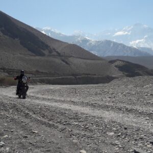
Exploring the terrain of a land is best done on a motorcycle and Nepal is a country with innumerable types of terrain. Nepal is also where the ice – cold, mighty Himalayas meet the lush green tropical region of the Terai plains. For the past few years Nepal has become a popular destination for motorcyclist around the world as it offers views of the magnificent Himalayas, colorful and vibrant cultures, ancient temples and monasteries, jungle safari in search of the elusive tiger and more…
This ride is one of the ultimate rides in the rain shadow part of the wind-swept desert landscape of the Himalayas with views of implausible gorges, high passes and enormous vistas passing through authentic Tibetan villages, barren ridges, eroded cliffs and Moraine valleys. Its landscape is unrivaled for it has a stupendous wilderness, pristine scenery, snowcapped peaks, spectacular monasteries and caves.
Nepal is occupying only 0.1 % of the earth and is home to:
- 2 % of all the flowering plants in the world.
- 8 % of the world’s population of birds (more than 848 species).
- 4 % of mammals on earth.
- 11 of the world’s 15 families of butterflies (more than 500 species).
- 600 indigenous plant families.
- 8 of the 14 highest (8000 m) peaks of the world
NEPAL AT A GLANCE:
Official Name: Federal Democratic Republic of Nepal
Area: 147, 181 square kilometers.
Geography: Situated between China to the north and India to the south, east & west. Highest point Mt. Everest (8848.86 m) and the lowest Keshena (60 m above sea level)
Capital: Kathmandu – surrounded by four hills – Fulchowki, Chandragiri, Shivapuri and Nagarjun. Kathmandu valley has three major cities Kathmandu, Bhaktapur and Patan. Situated at the altitude of 4,500 feet above sea level, Kathmandu is home to seven UNESCO World Heritage Sites. Before the unification of Nepal in the 18th century, the three cities were independent states ruled by the Malla Kings.
Population: 23.1 million (according to the census of 2001)
Language: Nepali is the national language. However English is spoken by many.
People/Religion: Nepal has more than 105 ethnic groups with diverse culture, traditions and lifestyle. Nepali people can be divided into two distinct groups: Indo-Burman and Mongoloid. Nepal is a secular state with majority of people following Hinduism. However, people practicing Buddhism, Christianity and Islam among others live in a good harmony.
Politics: Multi-Party System of Democracy.
Admin Division: Nepal is divided into 7 federal Provinces. 77 District and 753 Local Level governments
Climate: Nepal has four seasons, namely; (1) winter – December to February,(2) Spring – March to May, (3) summer – June to August & (4) Autumn – September to November. Nepal can be visited the whole year around.
What to wear: Light weight clothing is recommended for May through October, Warm garments are required in October through till March. An umbrella or a raincoat is a must for the rainy season.
ITINERARY
Day 01: Welcome to Kathmandu (1370m)
Upon arrival met by representative at the airport and later board the waiting vehicle and drive to Hotel.
15:00 Hrs: Met by the Road captain and introduction to the Royal Enfield Motorcycles. There will be a short briefing about the safety and the proper speed to ride on the roads of Nepal followed by a question and answer session.
18:00 Hrs: Board the waiting vehicle and proceed for a welcome dinner at typical Nepali Restaurant.
After dinner, board the waiting vehicle and drive to Hotel.
Overnight at Hotel
Day 02: Ride Kathmandu to Bandipur (1030m/4.45Hrs/150km)
After breakfast, we negotiate the traffic out of the Kathmandu city and ride out of the valley at the cross section of the ring road at Kalanki, continue south towards check post at Nagdhunga, just past Thankot.
From here, the road ascends twisting and turning as we negotiate the traffic to Naubise, 26 kilometer marker (about 17 kilometers from Nagdhunga). Then the road becomes much wider and smoother. We continue riding and arrive at Mugling, the junction where the highway bifurcates, south to Chitwan and west to Pokhara. Head west crossing the bridge and follow the Marshyangdi River for about 25 kilometers to Dumre town. Continue for another ½ kilometer and then take the left turn to Bandipur Township.
This 8 kilometer ride is a pleasant one as we continue to ascend on a winding path. Upon arrival check into the hotel and rest of the afternoon is free to relax and explore around the Bandipur village.
Bandipur is a picturesque town nestled in the himalayan foothills of Nepal, a land as famous for its natural beauty as for the hospitality of its people. Bandipur has been described as a natural view tower as one can view the spectacular panorama of the entire Annapurna range including the peaks of Dhaulagiri, Manaslu and Langtang from here. Apart from the stunning views of the Himalaya and the Marsyangdi Valley, a visit to the town is an opportunity to get a close look at Newar cultural life.
Overnight at Hotel
Day 03: Ride from Bandipur to Tatopani (6.14Hrs/175km/1190m)
Firstly, descend to the main highway near Dumre and then head west following the Marshyangdi River for a while and then slowly ascend through terraced agricultural lands and small road side villages. At the outskirts of Pokhara, we are greeted with views of the Annapurna Mountain range including the famous Fish Tail Mountain.
Pokhara stands at 827 meters above sea level and is an ideal vacationer’s paradise. With its crystal clear lakes, magnificent views of the Annapurna Mountain Range and its bustling but quaint lake side bazaar, it is a major tourist attraction. From here most of the treks starts for the western region and is a haven for people who wants to relax in this serene mountain beauty. The Annapurna mountain range is impressive by any standard and looming ahead to take the center stage is Machapucchre or “Fish Tail Mountain”, which gets its name from the shape of its summit and flanking it from either side are the great mountains of the range including Annapurna I (8091 m), the first 8000 m peak to be scaled in 1950. The range continues to meet the Lamjung Himal in the east while to its west looms the massive dome of Dhaulagiri (8161 m).
Leave Pokhara and ride towards Beni (approx. 83 Kilometers) on the Baglung Highway. This section of the ride provides fantastic mountain vistas, picturesque terraced farmlands and an opportunity to walk on one of Nepal’s famous suspension bridges. At Mal Dhunga, leave the main highway by taking the right trail and follow a dusty graveled path all the way to Beni, the district headquarters of Myagdi District in Dhaulagiri Zone. It is located on the confluence of Kali Ghandaki and Myagdi rivers at an altitude of 799 meters and is a bustling town lined with stores, restaurants, hotels and various government offices.
From here, the road is unpaved and dusty with potholes in several places. Unpaved, graveled rough road poses a real challenge for riders and makes it more difficult with the occasional river crossings.
Ascend gradually through the Kali Gandaki gorge, the deepest gorge in the world. There is a continuous change in the topography with every twist and turn until our arrival at Tatopani.
Tato” means ‘hot’ and “Pani” means ‘water’, a name earned courtesy of the hot springs and is a popular place for trekker’s to relax and dip their weary bodies in the natural hot springs.
Upon arrival at Tatopani, check into Hotel
Overnight at Hotel
Day 04: Ride from Tatopani to Muktinath (5Hrs/64km/3800m)
After Breakfast, set out on the trail by following the Kali Gandaki River and passing the Thakali and Magar Villages to Dana (4750 ft. / 1446 m.) famous for its beautiful cascading waterfall. Steeply ascend to Ghasa (6600 ft./ 2012m) and continue the ride on a dusty and one of the difficult section of the road towards Jomsom via the Thakali villages of Tukuche and Kalopani. Enroute, there are fantastic views of the Mt. Dhaulagiri (8167 m), Tukuche (6920m), and Nilgiri (7061m).As we pass between the Dhaulagiri and the Annapurna mountain range, a dramatic change in vegetation is witnessed from green forests, to dry arid desert. It takes gradual acclimatizing with the surrounding. The Thakali’s are the dominant tribe of the valley, related to the Gurung and Magars of the southern slopes.
As soon as we pass Ghasa we will come to a place known as Dhaiku where we have to cross the bridge. After riding approximately for 10 kilometers via Lete we will come to our today’s destination Kalapani. Kalapani is scaled to be at 2530 meters. One can enjoy a very beautiful view of Mt. Nilgiri and Mt. Tukuche
This day’s journey is a tough one but the scenic views of the rugged landscape, beautiful cascading waterfalls, orange and apple orchards, scattered roadside villages, ancient Buddhist monasteries all make it ‘One Hell of a Ride”.
Jomsom (2700 m) is more correctly known as Dzongsam or New Fort. It spreads over both the banks of the Kali Ghandaki. The towering peaks of Dhaulagiri and Nilgiri form an attractive backdrop. Being the district headquarters, it is primarily an administrative and commercial center with government officials and merchants rubbing shoulders with the local inhabitants of the region, known as the Thakalis. Jomsom is the Administrative center of the Mustang region and the gateway to the Annapurna region. A land of mystique, the rugged peaks of the Annapurna, Nilgiri and Dhaulagari gaze down in their awesome splendor at weathered landscapes that contrast with the deep river ravines over noisy riverbeds. Jomsom is a mixture of hard work, social frivolity tempered by culture founded on deep religious traditions. It has the only airport that operates daily scheduled flights to Pokhara in the early mornings before the winds build up.
From here continue ride passing through the village, past the High Altitude Mountain Warfare School of the Royal Nepal Army and through several restaurants, bhattis and a hospital. We pass through the old Jomsom village which boasts of several lodges, restaurants school and government offices. At the end of the village the valley opens wide, take the left side of the trail just after crossing the three ruined chorten and continue on the east bank of the Kali Ghandaki River. After about 20 minutes, arrive at Ekklaibhatti a small village with few lodges. There are two trails here. The left will lead to Kagbeni while the right one leads to Muktinath. We take the right trail and continue to ascend slowly to the settlement of Jharkot, which has a fort “Kot”.
Kagbeni at an altitude of 2800m is a fascinating medieval village with closely packed mud brick houses, dark alleys and imposing chortens lies along the Around Annapurna Trekking route and is the gateway to Upper Mustang. The village stands in a little green oasis dominated by its red monastery. Though the village has a very medieval look, it can provide all the modern amenities that a traveler requires. This is the only village after Jomsom where there is an internet facility for communication with the outside world. This village also boasts of a Monastery. The monks here are of the yellow hat or the Gelukpa Sect and have only recently opened their monastery to visitors with a legitimate entrance fee of Rs 100, which they collect for the maintenance of their school.
From here, another 15 minutes of an ascent on the desert plateau with fantastic views of the Himalayan high desert landscape which finally brings us to Muktinath.
Upon arrival at Muktinath, check into Hotel.
Late PM: Visit Muktinath Temple
The Muktinath Temple is a sacred place both for Hindus and Buddhists and is located at an altitude of 3,710 meters at the foot of the Thorong La (5416 m Pass), Mustang district, Nepal. The site is close to the village of Ranipauwa, which sometimes mistakenly is called Muktinath as well.
The Hindus call this sacred place MuktiKshetra, which literally means “Place of Salvation”. This temple is considered to be the 105thamong the available 108 Divya Desam. The ancient name of this place, before the Buddhist origin was known as Thiru Saligram.
In Muktinath-Chumig Gyatsa all the elements are represented and for this and reasons unseen, yogis from both religions do their meditation at Muktinath. For Tibetan Buddhists, Muktinath (Chumig Gyatsa) is a place of Dakinis (goddess known as Sky Dancers). It is of great importance for Buddhists as Chumig Gyatsa is one of the 24 Tantric places.
For Hindus, beside the natural fire representing Brahman and the holy waters, the central meaning of the Muktinath area is veneration of the god Vishnu in the form of ammonites (shilas) called Salagrama – Shilas.
There are many stories which tell of Vishnu turning into stone and all of them are closely connected to the holy Kali Ghandaki River. According to contemporary geologists, the Salagrama – silas (found at the banks and river bed of the holy river Kali Ghandaki) are fossils of a prehistoric insect. This insect is mentioned in the Bhavisya Purana. Therein, Tulasi, the sacred plant so dear to Vishnu, cursed Vishnu to become a stone during one act of their eternal lila. Vishnu said, “To fulfill your curse, I will become a stone (Salagrama-sila) and will always live on the banks of the Ghandaki River. The millions of Vajrakita worms that live at that place will adorn those stones with the signs of my chakra by carving them with their sharp teeth”.
After the sightseeing tour of Muktinath Temple descend down to the Ranipauwa (Main Bazaar of Muktinath).
Overnight at Hotel
Day 05: Ride back from Muktinath to Tatopani (5Hrs/64km/1190m)
After Breakfast, ride out of Muktinath towards Tatopani.
(Note: The Kaligandaki Valley becomes increasingly windy during the day as the winds blows south to north and makes it difficult for travelers)
After spending some time at Kagbeni continue ride to Jomsom (approx. 11 Km) but we continue further 25 kilometers, about 1 ½ hour slow ride to Kalopani via Marpha Village. From Here we ride through Marpha village at an elevation of 2670 meters. Marpha is famous for its apple orchards and apple products. This large Thakali village exhibits the typical Thak Khola architecture of flat roofs and narrow paved alleys and passageways. It also has a monastery.
After ride another 1 to 1 ½ hour to Kalopani then, we stop lunch at Kalopani. After lunch continue our ride to Tatopani
PM: Visit Hot Spring at Tatopani.
Overnight at Hotel
Day 06: Ride Tatopani to Pokhara via Beni (810m/124kms/5hrs)
After breakfast retrace the route till Pokhara Lunch at Beni / Nayapul.
Upon arrival at Pokhara check in to the hotel and rest of the day is free to relax and explore around the lake Bazaar.
Overnight at Hotel
Day 07: Free day in Pokhara
Free day to relax and explore around the lake bazaar for the souvenir shopping or sightseeing tour around city. Adventure activities like paragliding, bungee, ultra-light; zip flyer etc. can be performed in Pokhara.
Overnight at the Hotel
Day 08: Ride from Pokhara to Nuwakot (6Hrs/182.2km/1022m)
After breakfast met by the road captain at the hotel lobby and later ride 196Kms to Nuwakot. This day’s ride is mostly on the Pokhara/Kathmandu highway and we ride 90Kms to arrive at Mugling. From Mugling head north towards Kathmandu and arrive at Galchi (55Kms), a non-descript roadside village located at the cross section and the road on the right follows the Trishuli River into the Trishuli Bazaar.
The beauty of the area is not easily forgotten. The rolling hills, the Trishuli River, ethnic villages, suspension bridges all make it a very interesting ride. A little after Bahun Besi, the small village of Kosh kade is located on the other side of the suspension bridge which is the venue for annual Bullfighting festival that takes place during Maghe Sakranti festival in January.
In an about 45 mins of scenic ride arrive at the suspension bridge and enter a busy and populated settlement of Devi Ghat. Then continue for another kilometer to meet up with the main road from Trishuli Bazaar. From here, the road is black topped and riding along a path lined with pine trees for another 10 kilometers brings us to the famous Trishuli Bazaar.
The name, Nuwakot, is made up of two words ‘nawa’ and ‘kort’. Nawa means nine in Nepali and ‘kort’ means sacred religious site at the top of the hill. The district accordingly has 9 nine hills over which various deities are said to dwell thus overseeing and protecting Nuwakot. This has led to Nuwakot often being called “City of nine hills”. The place has carried a long history of the entire country Nepal.
Upon arrival at Nuwakot check into the hotel
Overnight at the Nuwakot Famous Farm, Nuwakot
Day 09: Ride Nuwakot to Kathmandu (72Kms/3hrs)
AM: Sightseeing tour of Nuwakot Durbar (Palace) and surrounding. The Saat Talle Durbar or “The Seven Storied Palace” is Located in Bidur municipality of Kathmandu’s neighboring hill district Nuwakot. This old palace fortress was built by Prithivi Narayan Shah during his quest to conquer Kathmandu. A tall looming figure on the top of a hill, this palace is composed of raw history. Made of bricks with wooden internal structures, this building is built with old Newari aesthetics combined with a militaristic approach. If one was to study the layout of the building then one would notice that this palace was a quasi-fortress:
1st floor: – Reception for the museum.
2nd floor: – This floor contains a room used for various religious purposes, including daily (nitya) puja and pujas during certain festivals.
3rd floor: – This floor contains the living quarters of the king and his two wives. The rooms of the wives were designed in such a way that they could be entered only from the king’s room. A balcony encircles the entire floor from which provides a panoramic view of the surrounding hills and the valleys carved by Tadi and Trisuli rivers.
4th floor: – This floor contains a dimly lit room where a small battalion was supposedly kept to ensure the king’s safety in the lower (4th) floor.
5th floor: – This floor comprises of a large feast room where the king carried out social functions.
6th floor: – This floor is a dungeon of sorts. With four foot high ceilings, Rajdrohi (Traitors) were kept in captivity and possibly tortured here.
7th floor: – This is the smallest floor and is called “Burja” (Burjis an Arabic word which means tower, and the Burja room is definitely a rooming the tower) and serves as a place where a guard(s) was kept to look out for trouble and blow the bugle when necessary.
After lunch, the 72 kilometer ride to Kathmandu is an interesting one. Firstly, we retrace our ride for about 10 minutes through the hustle and bustle of the Trishuli Bazaar and then take the road to Kakani. Firstly, it is a steep winding descent but the scenery is fantastic.
As one comes to the top of the ridge at Rani Pauwa, there are signs that points to the trout farms which have been a blessing in disguise for the economy of the region. The cool mountain air, the cold waters of fast flowing mountain streams has been ideal for trout farming and people all the way from Kathmandu come here on weekends to enjoy this delicacy. The farms here supply much of the requirements of the restaurants and hotels of the Kathmandu City.
Deep friend trout with “Piro Golbheda ko Achar” (hot and spicy tomato pickle) is just what the doctor recommends and is accompanied by a salad of fresh radish and carrots, another favorite from this region.
The route from Rani Pauwa slowly descends via Kakani to Balaju. The sunset over Mt. Langtang, Ganesh Himal, Dorji Lakpa etc. from Kakani is magnificent. Enroute, there are steep bends and descents and so the riders need to be extra careful with the oncoming traffic from Kathmandu. The army check post below Nagarjung checks everyone for any illegal plants or animals. As one descends into the Kathmandu valley, the view of the Kathmandu City, a cluster of dense concrete jungle greets us and we sadly mill into the traffic at Gongabu to slowly negotiate our way to the hotel.
EVE: Farewell Dinner
Overnight at the Hotel, Kathmandu
Day 10: Final departure
After breakfast, met by representative and transferred to the airport for the onward flight home. (Reporting time is at least 3hrs before flight time)
***End of Arrangements***


")


Reviews
There are no reviews yet.