ITINERARY
DETAILED ITINERARY
Day 01: Arrive at Kathmandu (1350m)
Upon arrival met by representative at the airport and later board the waiting vehicle and drive to Hotel.
18:00 Hrs: A short briefing about the Ride will be carried out at the hotel lobby. Later board the waiting vehicle and proceed for a welcome dinner at typical Nepali Restaurant where we’ll experience authentic cuisine and cultural performances.
Overnight at Hotel Royal Singi, Kathmandu
Day 02: Ride Kathmandu to Begnas Lake (650m/193kms/7hrs)
After a hearty breakfast in Kathmandu, we set off on our two-wheeled adventure, leaving behind the hustle and bustle of the capital. The journey begins on the busy Tribhuvan Highway, gradually unfolding into open roads flanked by lush hillsides and terraced farms. As we descend from the Kathmandu Valley, we cruise along the Prithvi Highway which offers spectacular view of river gorges, charming roadside villages, and the distant Himalayan skyline. We take a scenic detour at Dumre, leaving the main highway behind. The route narrows and leads us through the peaceful town of Sundarbazar, where rural Nepal greets us with authentic charm—mud houses, waving children, and traditional ways of life untouched by time. This section of the ride provides a sense of serenity, as we cruise through forested patches and terraced hillsides with minimal traffic.
As we continue westward, the air becomes warmer and more tropical. We approach the tranquil Begnas Lake, a hidden gem nestled in the foothills of the Annapurna Range. Begnas is peaceful and untouched—a perfect retreat to unwind after a long day’s ride. The road here is narrow but blacktopped and well-maintained, gently descending toward the lakeshore. Upon arrival, you’ll be welcomed by the serene beauty of the lake and surrounding hills. The emerald waters reflect the soft evening light, inviting you for a quiet walk, some meditation, or simply a refreshing drink by the water. Dinner is served at the lakeside resort, where the calm breeze and distant sounds of nature set the perfect tone for a restful night.
Route: Kathmandu – Naubise – Mugling – Dumre – Sundarbazar – Begnas Lake
Dinner and Overnight at Begnas Lake Resort or Similar
Day 03: Ride Begnas Lake to Kalopani (2470m/150km/5hrs)
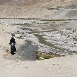
After a peaceful morning by the serene waters of Begnas Lake, the journey heads westward toward the Annapurna region. The ride begins with a smooth tarmac road as you cross Pokhara and continue towards Beni via Kusma. This section of the ride is scenic, passing through vibrant towns, suspension bridges, and views of the Modi River. At Beni, the road condition changes significantly—from paved to gravel and dirt, with occasional rocky and dusty stretches, especially as you ascend along the Kali Gandaki Gorge.
From Beni, the trail follows the Kali Gandaki River upstream, moving through villages like Tatopani and Dana. The landscape becomes more dramatic, with waterfalls cascading down steep cliffs and glimpses of the Annapurna and Dhaulagiri ranges peeking through the trees. As you approach the village of Ghasa, you’ll encounter a key checkpost where vehicle documents, driver’s licenses, and travel permit (especially ACAP and TIMS cards) are usually inspected. This checkpoint is essential, particularly for travelers heading toward Jomsom and Upper Mustang. It’s advisable to keep all permits and identification readily accessible for a smooth process.
Post-Ghasa, the road gets narrower and rougher with occasional landslide-prone sections, but the natural beauty intensifies. You gradually climb through pine forests and alpine terrain until you reach Kalopani, a charming village nestled at 2470 meters, offering breathtaking views of Dhaulagiri, Nilgiri, and Annapurna I. The cool mountain air and tranquil setting make it a rewarding end to a challenging ride.
Route: Begnas Lake Resort – Kushma – Maldhunga – Beni – Tatopani – Kalopani
Dinner and Overnight at See you Lodge, Kalopani
Day 04: Ride Kalopani to LoManthang (3800m/140km/7hrs)
Today marks one of the most exhilarating and scenic rides of the entire journey, as you leave the lush pine-covered village of Kalopani (2470m) and make your way to the ancient walled kingdom of Lo-Manthang (3840m) in Upper Mustang. The ride begins with a descent through pine forests and traditional Thakali villages, before arriving at Jomsom (2743m)—a bustling administrative hub of Mustang where your first Trekking Permit (ACAP) checkpost is located. Here, all riders must present their permits for verification. Continuing the ride, you follow the windswept Kali Gandaki riverbed northward, reaching Kagbeni (2800m)—a picturesque village and the official gateway to Upper Mustang.
At the Kagbeni checkpost, your Restricted Area Permit (RAP) is thoroughly checked before entering the restricted region. From Kagbeni, the route begins to transform dramatically into a barren, high-altitude desert with steep cliffs and eroded rock formations. The road becomes increasingly rugged and dusty, with narrow dirt trails carved into the mountainside, offering breathtaking views of the Nilgiri and Dhaulagiri ranges. Further along, you reach Chuksang (2980m), the third permit checkpost where another RAP verification is mandatory. After crossing the Kali Gandaki via steel suspension bridges and ascending a series of switchbacks, you pass through remote villages such as Samar, Ghiling, and Tsarang, each offering short breaks and cultural glimpses of Tibetan-influenced architecture. The final stretch to Lo-Manthang is a thrilling ascent over barren ridgelines and deep canyons, finally arriving at the legendary walled city, nestled on the high-altitude plateau of Upper Mustang. The sense of remoteness, the stark Himalayan desert landscape, and the preserved Tibetan Buddhist culture make this day truly unforgettable.
Route: Kalopani – Jomsom – Kagbeni – Samar – Tsarang – LoManthang
Dinner and Overnight at Hotel Mandala, Lomanthang
Day 05: RIDE AROUND LOMANTHANG (4460M/50KMS) & VISIT WALLED CITY
Today is a magical day of immersion into the ancient Tibetan-Buddhist culture and surreal landscapes of Upper Mustang. After an early breakfast, we set out on a high-altitude excursion, riding across dramatic wind-carved valleys and barren hills beyond Lo-Manthang. Our first stop is the Old Samzhong (Samjong) Village, a secluded and spiritual settlement nestled in a remote gorge. This small village offers an authentic glimpse into the timeless lifestyle of Mustang’s Mountain people, where ancient traditions, mud houses, and terraced fields blend seamlessly with the raw natural beauty.
Continuing our journey, we ride to Chhoser Cave, also known as Jhong Cave. This remarkable five-story cave complex carved into a sheer cliff face features more than 40 interconnected rooms. Once used as a monastery and ancient residence, Chhoser Cave stands as a testament to the ingenuity of early Himalayan settlers and offers a fascinating walk-through time.
After soaking in these extraordinary sites, we return to Lo-Manthang in the late afternoon. As the golden sun casts shadows over the arid land, we stroll through the walled city of Lo-Manthang, a fortified medieval capital with narrow alleys, whitewashed homes, and age-old gompas. The city’s towering walls, once built to guard the kingdom, still stand tall with echoes of Mustang’s royal legacy.
Overnight at the Hotel Mandala, LoManthang
Day 06: RIDE LOMANTHANG TO MUKTINATH (3800m/100km/6hrs)
Today’s ride offers one of the most culturally rich and visually stunning sections of the entire journey. Departing from the ancient walled city of Lo-Manthang, the trail winds through barren high-altitude deserts, rugged cliffs, and deep canyons. You will take the alternative scenic route via sacred Ghar Gumba, one of the oldest monasteries in Mustang, believed to be built by Guru Rinpoche and Dhakmar—famous for its striking red cliffs shaped by centuries of wind erosion. The road is completely off-road, rough and dusty, with several steep climbs and descents, requiring careful handling of your motorcycle. The views along this stretch are surreal, with expansive plateaus, hidden caves, and distant snow peaks all around. Eventually, you descend backtracing same rout till Kagbeni and a short and beautiful ride will take you into the holy village of Muktinath, revered by both Hindus and Buddhists, where you’ll visit the sacred Muktinath Temple and the eternal flame.
Late PM: Visit Muktinath Temple
The Muktinath Temple is a sacred place both for Hindus and Buddhists and is located at an altitude of 3,710 meters at the foot of the Thorong La (5416 m Pass), Mustang district, Nepal. The site is close to the village of Ranipauwa, which sometimes mistakenly is called Muktinath as well. The Hindus call this sacred place MuktiKshetra, which literally means “Place of Salvation”. This temple is considered to be the 105thamong the available 108 Divya Desam. The ancient name of this place, before the Buddhist origin was known as Thiru Saligram.
In Muktinath-Chumig Gyatsa all the elements are represented and for this and reasons unseen, yogis from both religions do their meditation at Muktinath. For Tibetan Buddhists, Muktinath (Chumig Gyatsa) is a place of Dakinis (goddess known as Sky Dancers). It is of great importance for Buddhists as Chumig Gyatsa is one of the 24 Tantric places. For Hindus, beside the natural fire representing Brahman and the holy waters, the central meaning of the Muktinath area is veneration of the god Vishnu in the form of ammonites (shilas) called Salagrama – Shilas. There are many stories which tell of Vishnu turning into stone and all of them are closely connected to the holy Kali Ghandaki River. According to contemporary geologists, the Salagrama – silas (found at the banks and river bed of the holy river Kali Ghandaki) are fossils of a prehistoric insect. This insect is mentioned in the Bhavisya Purana. Therein, Tulasi, the sacred plant so dear to Vishnu, cursed Vishnu to become a stone during one act of their eternal lila. Vishnu said, “To fulfill your curse, I will become a stone (Salagrama-sila) and will always live on the banks of the Ghandaki River. The millions of Vajrakita worms that live at that place will adorn those stones with the signs of my chakra by carving them with their sharp teeth”. After the sightseeing tour of Muktinath Temple descend down to the Ranipauwa.
Route: LoManthang – Ghar Ghumba – Dhakmar – Kagbeni – Muktinath
Overnight at Hotel Grand Shambala or Similar, Muktinath
Day 07: Ride Muktinath to Tatopani (1190m/70kms/5hrs)
After an early breakfast, we begin our descent from the sacred village of Muktinath (3750m), bidding farewell to the arid, windswept landscapes of the Upper Mustang. The day’s ride is a thrilling journey down the Kali Gandaki Valley, retracing the route through Jharkot and Kagbeni, with dramatic views of snow-capped peaks such as Nilgiri, Dhaulagiri, and Tukuche towering above.
As we pass through Jomsom (2743m), the administrative hub of Mustang, we may experience strong afternoon winds—typical of this trans-Himalayan corridor. The trail continues to the charming apple capital of Marpha, where whitewashed stone houses and narrow alleys offer a glimpse into traditional Thakali culture. From here, the road descends steadily through Tukuche and Larjung, following the deep gorge carved by the Kali Gandaki River—one of the world’s deepest gorges, framed between the Annapurna and Dhaulagiri massifs. The terrain today is mostly rugged and rocky, especially between Jomsom and Ghasa, with sections of loose gravel, river crossings, and narrow cliff-side bends demanding careful riding. Beyond Ghasa, the road improves, winding through lush green hills and rhododendron forests as we gradually descend into a warmer subtropical climate.
We arrive at Tatopani (1190m)—literally meaning “hot water”—in the late afternoon. This peaceful village is renowned for its natural hot springs, located right beside the roaring Kali Gandaki River. It’s the perfect place to soak your tired muscles in therapeutic mineral waters after several days of high-altitude off-road riding.
Route: Muktinath → Jharkot → Kagbeni → Jomsom → Marpha → Tatopani
Overnight at the Hotel Hotspring Resort, Tatopani
Day 08: Ride Tatopani to Pokhara (822m/105kms/5hrs)
After a hearty breakfast in the tranquil hot spring village of Tatopani, the ride begins with the roar of engines echoing through the Kali Gandaki Gorge—the world’s deepest. The initial stretch from Tatopani to Beni is a rugged descent on a rocky, off-road trail that demands both skill and concentration. This portion winds through traditional Thakali villages like Dana, Tiplyang, and Ghasa, offering glimpses of terraced fields, waterfalls, and hanging bridges set against the backdrop of the Annapurna and Dhaulagiri ranges.
As you pass through Beni, the administrative hub of the region, the road surface shifts dramatically—off-road gives way to a smooth blacktop. From here, the ride becomes more relaxed and fluid as you cruise along the paved Baglung Highway toward Kusma, crossing several steel trusses bridges and forested hills.
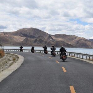
Continue through scenic towns like Nayapul, where trekkers begin their Annapurna journey. The final leg brings you gently down into the lush Pokhara Valley, where the air becomes warmer and the terrain flattens. Arriving back in Pokhara, the serene beauty of Phewa Lake welcomes you, with the Annapurna peaks mirrored on its calm waters.
After a challenging yet rewarding descent from the Mustang region, today’s ride offers the perfect blend of adventure and relief—trading rocky trails for smooth tarmac, high mountains for green hills, and remote villages for the lakeside tranquility of Pokhara.
Route: Tatopani – Dana – Ghasa – Beni – Kusma – Nayapul – Pokhara
Overnight at the Hotel Lake View Resort or Similar, Pokhara
Day 09: Pokhara Free Day
After days of thrilling rides through high mountain passes, deep gorges, and ancient Himalayan settlements, today offers a well-deserved rest day in the serene city of Pokhara — Nepal’s adventure capital and the gateway to the Annapurna region. Wake up to the gentle sounds of nature and enjoy a peaceful morning by Phewa Lake, with the majestic Machhapuchhre (Fishtail Peak) reflecting off its calm waters. This day is yours to explore at your own pace. You may choose to simply unwind at a lakeside café, indulge in a relaxing massage, or soak in the natural beauty that surrounds you.
For those seeking light adventure, Pokhara offers a variety of optional activities:
- Boating on Phewa Lake, gliding toward the Tal Barahi Temple located on a small island in the lake.
- A short hike or drive to the World Peace Pagoda, where panoramic views of the entire valley, lake, and snow-capped Himalayas await.
- Visit to Davis Falls, an underground waterfall, followed by the mysterious Gupteshwor Mahadev Cave located just across the road.
- For thrill-seekers, activities like paragliding, ultralight flights, or zip-lining can be arranged.
In the evening, stroll along the vibrant Lakeside promenade, dotted with boutique shops, art galleries, cozy bakeries, and live music venues. Whether you’re reflecting on the journey so far or planning your next adventure, Pokhara provides the perfect ambiance to relax and recharge.
Overnight at the Hotel Lake View Resort, Pokhara
Day 10: Ride Pokhara to Jagat (1300m/136kms/5hrs)
After enjoying a peaceful morning in the lakeside city of Pokhara, the ride kicks off with fresh energy as we head eastward on the Pokhara–Prithvi Highway. The first leg of the journey takes us through scenic countryside roads, passing through lush terraced fields, vibrant local villages, and along the banks of the Seti and Marsyangdi Rivers. The road is well-paved up to Dumre, offering a smooth and comfortable ride with picturesque views of the Annapurna and Lamjung ranges in the distance. At Dumre, we leave the main highway and divert north towards Besisahar, the gateway to the Annapurna Circuit. From here, the terrain begins to shift. The asphalt gives way to a mix of narrow gravel roads and unpaved stretches, surrounded by pristine forested hills and steep river valleys. We continue along the Marsyangdi River, crossing suspension bridges and encountering occasional waterfalls cascading beside the road.
As we ascend gently toward Jagat, the air turns crisper, and the scenery becomes more dramatic. The quaint village of Jagat, perched on a hillside and surrounded by cliffs and subtropical forest, marks the entrance into the Annapurna Conservation Area. The stone-paved alleys, traditional houses, and tranquil setting offer a striking contrast to the bustling towns left behind earlier in the day.
This day’s ride beautifully combines comfort and adventure — from smooth cruising to technical off-road trails — and introduces riders to the raw, natural beauty of the mid-hill Himalayan region. Dinner and overnight at Hotel Mandala in Jagat, where you can unwind in peaceful surroundings and prepare for the next leg of the highland adventure.
Route: Pokhara – Damauli – Besisahar – Jagat
Dinner and Overnight at Hotel Mandala, Jagat
Day 11: Ride Jagat to Manang (3550m/66km/3-4 hrs)
Today’s ride takes you deeper into the heart of the Annapurna region as we leave Jagat behind and ascend into the mystical landscapes of the high Himalayas. The journey begins with a rugged but thrilling ride along the Marsyangdi River, traversing narrow trails carved into cliff faces, cascading waterfalls, and dense pine forests. The road, primarily unpaved and rocky, demands both focus and skill, but rewards riders with dramatic scenery at every turn.
As we reach the village of Chame, the administrative center of the Manang District, we begin to sense the gradual transition from lush greenery to alpine terrain. From here, we continue upward to Dikur Pokhari, where the road forks, offering two routes to Manang. We take the more scenic and culturally rich upper trail via Pisang and Ngawal, bypassing the lower, faster road to soak in the true magic of the region.
The route through Upper Pisang (3300m) is especially captivating, with views of the majestic Annapurna II rising boldly to the south. The traditional stone houses, prayer wheels, and chortens reflect the deeply rooted Tibetan Buddhist culture. Continuing on, we pass through Ngawal Village (3660m)—a high-altitude settlement perched on a ridge that offers some of the best panoramic views of the entire Annapurna range. The spiritual ambiance, fluttering prayer flags, and ancient monasteries create an unforgettable experience.
The final stretch to Manang (3550m) is a gentle ride across open valleys and windswept trails. Surrounded by snow-draped peaks, glacial streams, and barley fields, Manang welcomes you with its unique blend of tradition, tranquility, and towering mountains. This highland village, nestled in a wide U-shaped valley beneath Gangapurna and Annapurna III, serves as a haven for trekkers and riders alike.
Route: Jagat – Chame – Pisang – Manang
Dinner and Overnight at Hotel Yeti, Manang
Day 12: FREE DAY IN MANANG (3550m)
Acclimatize and explore the Manang Valley. Ride or walk to Gangapurna Lake, visit local monasteries, or hike around Manang. Lunch at the hotel or nearby tea house.
Dinner and overnight at Hotel Yeti Manang.
Day 13: Ride Manang to Bandipur (1020m/150kms/7hrs)
Today marks a dramatic transition in both altitude and scenery as we descend from the high-altitude Himalayan village of Manang (3550m) to the culturally rich hilltop town of Bandipur (1020m). The day begins with an early breakfast in Manang, where the crisp mountain air and the surrounding peaks of Annapurna III, Gangapurna, and Tilicho Peak bid you farewell.
The ride kicks off along rugged trails and rocky descents through Pisang and Chame, passing pine forests, cascading waterfalls, and ancient mani walls. The road remains off-road and technical until we reach Jagat, demanding careful riding through narrow cliffs, landslide-prone zones, and suspension bridges.
Upon reaching Besisahar, the road smooths out into a blacktopped highway. From here, we cruise through the winding hilly roads of Lamjung and Tanahun districts, passing lush river valleys, small Magar and Gurung settlements, and terraced farmland. The contrast from the barren alpine landscapes of Manang to the subtropical greenery below is striking. As we ascend the final stretch toward Bandipur, a beautifully preserved Newari town perched atop a ridge, the view opens up to reveal sweeping panoramas of the Marsyangdi valley below and snowcapped peaks on the horizon. Bandipur is a living museum, with cobblestone lanes, traditional wooden houses, and a peaceful, car-free town center that offers a charming glimpse into Nepal’s architectural and cultural heritage. We arrive by late afternoon and settle into a historic inn, where warm hospitality, organic food, and a relaxed ambience await. Enjoy the evening soaking in the sunset views, visiting the local temples and bazaar, or simply unwinding on a balcony overlooking the hills.
Route: Manang – Chame – Besisahar – Dumre – Bandipur
Dinner and Overnight at Hotel Old Inn, Bandipur
Day 14: Free day in Bandipur
Enjoy a relaxed day in this charming heritage town. Walk the cobbled streets, visit the Thani Mai Temple for sunrise views, or a short ride around Bandipur.
Dinner and overnight at The Old Inn, Bandipur
Day 15: Ride Bandipur to Nuwakot (1020m/125km/5hrs)
After breakfast amidst the tranquil, timeless beauty of Bandipur’s hilltop village, we begin our journey toward the historic district of Nuwakot. Leaving behind the cobbled streets and Newari heritage of Bandipur, we descend through winding roads to rejoin the Prithvi Highway at Dumre. The initial stretch of the ride is smooth and scenic, following the Marshyangdi River as it flows southward, with green terraced hills and rural life unfolding along the roadside.As we ride eastward along the highway, we pass through bustling market towns like Mugling and Galchhi. From Galchhi, we leave the main highway and veer north toward the peaceful Trishuli valley. The road begins to narrow and become more undulating, offering a more intimate experience of rural Nepal. Along the way, you’ll see traditional villages, orange orchards, and glimpses of Himalayan foothills in the distance. The final ascent to Nuwakot is a picturesque ride through quiet ridges and forested hills. Nuwakot is a town steeped in history—it served as the capital of unified Nepal under King Prithvi Narayan Shah before Kathmandu. The town still preserves its cultural charm, with the iconic seven-story palace (Saat Tale Durbar), ancient temples, and beautifully restored traditional architecture.
Route: Bandipur – Dumre – Mugling – Galchhi – Trishuli – Nuwakot
Dinner and Overnight at The Famous Farm, Nuwakot
Day 16: Ride Nuwakot to Kathmandu (1350m/80km/3hrs)
After a peaceful night in the tranquil hills of Nuwakot, the journey back to Kathmandu begins with a scenic ride through the lesser-traveled countryside route via Chhahare and Tokha. As you leave the rustic charm of The Famous Farm, the road meanders through quiet villages, terraced farmlands, and lush forested sections. The initial stretch is a blend of dirt tracks and narrow blacktopped roads, offering a more intimate view of rural Nepal away from the main highways.
The route climbs gently through the ridge of Chhahare, a pristine and serene area known for its panoramic views of the surrounding hills and distant snow-capped peaks. With minimal traffic, this route gives you the chance to enjoy the rhythm of village life—locals tending to fields, children walking to school, and traditional homes dotting the hillsides.
As you approach Tokha, an ancient Newari town on the northern edge of Kathmandu Valley, the scenery shifts. Here, you begin to feel the slow re-entrance into urban civilization. The cobbled paths, red-brick buildings, and historical temples of Tokha offer a final taste of Nepal’s rich cultural tapestry before you descend into the bustling heart of Kathmandu.
The ride concludes at Hotel Royal Singi, where you can unwind and reflect on the incredible journey through Nepal’s diverse landscapes—from tropical lowlands and alpine deserts to high Himalayan plateaus and timeless hilltop towns.
Route: Nuwakot – Bidur – Chhahare – Tokha – Hotel
Overnight at Hotel Royal Singi or similar, Kathmandu
Day 17: Final Departure
After breakfast, met by representative and transferred to the airport for the onward flight home. You will get free before we drop you at the airport for the final departure. (Reporting time is at least 3hrs before flight time)
*** END OF ARRANGEMENT***


")


Reviews
There are no reviews yet.