ITINERARY
Day 01: Welcome to Kathmandu (1350m)
Upon arrival met by representative at the airport and later board the waiting vehicle and drive to Hotel.
18:00 Hrs: A short briefing about the tour will be carried out at the hotel lobby. Later board the waiting vehicle and proceed for a welcome dinner at typical Nepali Restaurant.
Overnight at Hotel Everest /Hotel Radission / Hotel Tibet International
Day 02: Drive Kathmandu to Besisahar (760m/177kms/5-6hrs)
After Breakfast, Met by the guide/escort from Sacred Summits (P) Ltd and the rest of the team at the hotel lobby and drive to Besisahar
We negotiate the traffic out of the Kathmandu city and drive out of the valley at the cross section of the ring road at Kalanki and then set out for check post at Nagdhunga, just past Thankot. From here, the road twists and turns as we negotiate the traffic and descend to Naubise, 26-kilometer marker (about 17 kilometers from Nagdhunga).
From here the road becomes much wider and smoother all the way to Kurintar, 103 kilometers from Kathmandu. We continue riding to Mugling and head west for 29 kilometeres towards Dumre by crossing the suspension bridge and following the Marshyangdi river for a while.
From Dumre we head towards north to Besisahar. Though it is short distance drive, you will have a most adventurous trip today and reach the most beautiful town named Besishahar which is a municipality and the district headquarters of Lamjung District in Gandaki Zone, Nepal.
Route: Kathmandu → Thankot → Naubise → Mugling → Dumre → Besisahar
Road Condition: Mostly blacktopped highway with some rough patches closer to Besisahar
Drive Time: Approximately 6 to 7 hours depending on traffic and stops
Dinner and Overnight at Hotel Himalaya Gateway Besisahar
Day 03: Drive Besisahar to Manang (3519m/99Km/7hrs)
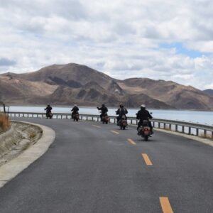
After Breakfast, the drive from Besisahar to Jagat (34km/2hrs) is one of the most difficult terrains. The path is a rocky single lane track with stones and occasional waterfalls. Deep gorges and valleys can be seen on the way as there is a gradual change in the scenery. This is a good trail for adventure and thrill seekers who like to challenge themselves. Motor biking on this route is one of the most exhilarating experiences one can be a part of as you pass through many notable settlements en route.
From Jagat, we will drive out to the valley of Manang. The drive is easy at first and then starts gets difficult as we move up. As we go forward, we reach Pisang village which almost feels like we have time traveled to the past. Beautiful houses and stoned paved path and the fluttering of many prayer flags glorify the natural beauty of Pisang. We also get magnificent views of the Annapurna massif against grasslands where wild horses and different cattle graze. There is the gradual change in the landscape where the colors of grey and green complement each other really well. We will pass through monasteries and small tea houses that offer basic but good accommodation for the many that come here. About riding for 4 hrs on a difficult road we reach manang.
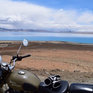
Manang District a part of Gandaki Pradesh, is one of the seventy-seven districts of Nepal. The district, with Chame as its district headquarters, covers an area of 2,246 km² and had a population (2011) of 6,538. The pass of Throung La at 5415 meters above the sea connects the district to Mustang district by providing a route between the towns of Manang and Muktinath. Manang district gets the least amount of rainfall among districts of Nepal as it lies to the north of the Himalayas which blocks monsoon air. The Manang Valley, which lies close to the Nepal-Tibet border, offers tremendous opportunities due to its rich natural flora and fauna.
Route: Besisahar → Chame → Pisang → Manang
Road Type: Rough, off-road mountain track (jeep trail)
Drive Time: 6–8 hours depending on road conditions, weather, and acclimatization stops
Dinner and Overnight at Hotel Yeti, Manang
Day 04: Drive Manang to Bandipur (1030m/146kms/7-9hrs)
After breakfast, Drive for a long yet scenic drive back to Bandipur.
The route is rugged and adventurous, tracing back along the Marsyangdi River through picturesque villages like Pisang, Chame, and Dharapani. Expect bumpy roads, waterfalls cascading over cliffs, terraced farms, and changing landscapes as you drop from alpine highlands to lush, green hills.
Bandipur is a picturesque town nestled in the himalayan foothills of Nepal, a land as famous for its natural beauty as for the hospitality of its people. Bandipur has been described as a natural view tower as one can view the spectacular panorama of the entire Annapurna range including the peaks of Dhaulagiri, Manaslu and Langtang from here. Apart from the stunning views of the Himalaya and the Marsyangdi Valley, a visit to the town is an opportunity to get a close look at Newar cultural life.
Route: Manang → Pisang → Chame → Besisahar → Dumre → Bandipur
Drive Type: High-altitude descent, combining rough off-road and blacktop highway
Drive Time: 7–9 hours depending on weather, road conditions, and breaks
Dinner and Overnight at Hotel Old Inn, Bandipur
Day 05: Drive Bandipur to Kalopani (2480m/145km/7hrs)
After Breakfast, set out on the trail and the drive from Bandipur to Kalopani takes you through diverse landscapes, from the rolling hills near Pokhara to the rugged terrain of the Kali Gandaki Valley. Pass through villages like Lumle and Beni, navigating winding roads with spectacular views of the Annapurna and Dhaulagiri mountain ranges. The route offers a mix of natural beauty and cultural experiences, with opportunities to see traditional villages, terraced fields. The drive culminates in Kalopani, a charming village with panoramic mountain views. From Bandipur till Baglung Maldhunga the road is fully tarmac only with some bumpy. At Mal Dhunga, we leave the main highway by taking the right trail and follow a dusty graveled path all the way to Beni, the district headquarters of Myagdi District in Dhaulagiri Zone. It is located on the confluence of Kali Ghandaki and Myagdi rivers at an altitude of 799 meters and is a bustling town lined with stores, restaurants, hotels and various government offices.
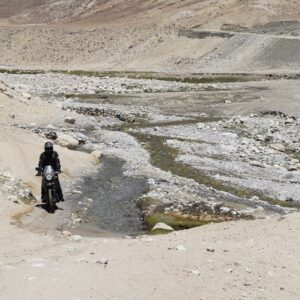
From here, the road is unpaved and dusty with potholes in several places. Unpaved, graveled rough road poses a real challenge for drivers and makes it more difficult with the occasional river crossings.
Ascend gradually through the Kali Gandaki Gorge, the deepest gorge in the world. There is a continuous change in the topography with every twist and turn until we arrive at Ghasa. The first checkpoint where we need to show our documents like ACAP permits and all. Ghasa is the starting section of Mustang district and from here Kalopani is just 8km in distance.
Route: Bandipur → Dumre → Pokhara → Beni → Tatopani → Kalopani
Drive Type: Mix of highway and off-road mountain driving
Drive Time: Approx. 7–9 hours depending on stops and road conditions
Upon arrival at Kalopani, check into the Hotel
Dinner and Overnight at See You Lodge, Kalopani
Day 06: Drive Kalopani to Muktinath to Tatopani (1200m/12okms/6-8hrs)
After Breakfast, set out for the rugged landscape, beautiful cascading waterfalls, orange and apple orchards, scattered roadside villages, ancient Buddhist monasteries all make it ‘One Hell of drive”.
Jomsom (2700 m) is more correctly known as Dzongsam or New Fort. It spreads over both the banks of the Kali Ghandaki. The towering peaks of Dhaulagiri and Nilgiri form an attractive backdrop. Being the district headquarters, it is primarily an administrative and commercial center with government officials and merchants rubbing shoulders with the local inhabitants of the region, known as the Thakalis. Jomsom is the Administrative center of the Mustang region and the gateway to the Annapurna region. A land of mystique, the rugged peaks of the Annapurna, Nilgiri and Dhaulagari gaze down in their awesome splendor at weathered landscapes that contrast with the deep river ravines over noisy riverbeds. Jomsom is a mixture of hard work, social frivolity tempered by culture founded on deep religious traditions. It has the only airport that operates daily scheduled flights to Pokhara in the early mornings before the winds build up.
From here continue drive passing through the village, past the High Altitude Mountain Warfare School of the Royal Nepal Army and through several restaurants, bhattis and a hospital. We pass through the old Jomsom village which boasts of several lodges, restaurants school and government offices. At the end of the village the valley opens wide, take the left side of the trail just after crossing the three ruined chorten and continue on the east bank of the Kali Ghandaki River. After about 20 minutes, arrive at Ekklaibhatti a small village with few lodges. There are two trails here. The left will lead to Kagbeni while the right one leads to Muktinath. We take the right trail and continue to ascend slowly to the settlement of Jharkot, which has a fort “Kot”.
Kagbeni at an altitude of 2800m is a fascinating medieval village with closely packed mud brick houses, dark alleys and imposing chortens lies along the Around Annapurna Trekking route and is the gateway to Upper Mustang. The village stands in a little green oasis dominated by its red monastery. Though the village has a very medieval look, it can provide all the modern amenities that a traveler requires. This is the only village after Jomsom where there is an internet facility for communication with the outside world. This village also boasts of a Monastery. The monks here are of the yellow hat or the Gelukpa Sect and have only recently opened their monastery to visitors with a legitimate entrance fee of Rs 100, which they collect for the maintenance of their school.
From here, another 15 minutes of an ascent on the desert plateau with fantastic views of the Himalayan high desert landscape which finally brings us to Muktinath.
Visit Muktinath Temple
The Muktinath Temple is a sacred place both for Hindus and Buddhists and is located at an altitude of 3,710 meters at the foot of the Thorong La (5416 m Pass), Mustang district, Nepal. The site is close to the village of Ranipauwa, which sometimes mistakenly is called Muktinath as well.
The Hindus call this sacred place MuktiKshetra, which literally means “Place of Salvation”. This temple is considered to be the 105thamong the available 108 Divya Desam. The ancient name of this place, before the Buddhist origin was known as Thiru Saligram.
In Muktinath-Chumig Gyatsa all the elements are represented and for this and reasons unseen, yogis from both religions do their meditation at Muktinath. For Tibetan Buddhists, Muktinath (Chumig Gyatsa) is a place of Dakinis (goddess known as Sky Dancers). It is of great importance for Buddhists as Chumig Gyatsa is one of the 24 Tantric places.
For Hindus, beside the natural fire representing Brahman and the holy waters, the central meaning of the Muktinath area is veneration of the god Vishnu in the form of ammonites (shilas) called Salagrama – Shilas.
There are many stories which tell of Vishnu turning into stone and all of them are closely connected to the holy Kali Ghandaki River. According to contemporary geologists, the Salagrama – silas (found at the banks and river bed of the holy river Kali Ghandaki) are fossils of a prehistoric insect. This insect is mentioned in the Bhavisya Purana. Therein, Tulasi, the sacred plant so dear to Vishnu, cursed Vishnu to become a stone during one act of their eternal lila. Vishnu said, “To fulfill your curse, I will become a stone (Salagrama-sila) and will always live on the banks of the Ghandaki River. The millions of Vajrakita worms that live at that place will adorn those stones with the signs of my chakra by carving them with their sharp teeth”.
After the sightseeing tour of Muktinath Temple drive to Tatopani via Kagbeni (1200m/80kms/6hrs). Drive down to Kagbeni (2800 m) which is the gateway to Upper Mustang. (Note: The Kaligandaki Valley becomes increasingly windy during the day as the winds blows south to north and makes it difficult for travelers.
After spending some time at Kagbeni continue drive to Jomsom (approx. 11 Km) but we continue further 25 kilometers, about 1 ½ hour slow drive to Kalopani via Marpha Village.
Marpha at an elevation of 2670 meters. Marpha is famous for its apple orchards and apple products. This large Thakali village exhibits the typical Thak Khola architecture of flat roofs and narrow paved alleys and passageways. It also has a monastery.
After lunch drive another 1 to 1 ½ hour to Kalopani. Upon arrival at Kalopani we continue our drive to Tatopani via Ghasa, Pairathaplo and Dana. From Ghasa most of the drive is downhill.
Tato” means ‘hot’ and “Pani” means ‘water’, a name earned courtesy of the hot springs and is a popular place for trekker’s to relax and dip their weary bodies in the natural hot springs.
Upon arrival at Tatopani check in to the lodge and rest of the evening is free to relax and explore around the Tatopani village.
Route: Kalopani → Marpha → Jomsom → Kagbeni → Muktinath → Tatopani
Drive Type: Mountain off-road track with riverbeds, stone-paved roads, and high-altitude sections
Drive Time: Approx. 2.5–3.5 hrs to Muktinath, then 3–4 hrs down to Tatopani
Dinner and Overnight at the Hotel Natural Hot Spring, Tatopani
Day 07: Drive Tatopani to Pokhara via Beni (810m/115kms/5hrs)
After breakfast retrace the route till Pokhara Lunch at Beni / Nayapul.
Upon arrival at Pokhara check in to the hotel and rest of the day is free to relax and explore around the lake Bazaar.
Route: Tatopani → Beni → Kushma → Pokhara
Drive Type: Mountain road transitioning to paved highway
Drive Time: Approx. 4–5 hours depending on road conditions and stops
EVE: Free on own
Overnight at Hotel Lakeview Resort or Similar
Day 08: Drive Pokhara to Kathmandu (210kms/8hrs)
After breakfast, Drive 210 kms to Kathmandu. Today the drive is mostly on the Pokhara/Kathmandu highway and we drive 100Kms to Mugling. Here we stop for lunch break. After Lunch we continue our drive towards Kathmandu for another 110 kilometer.
EVE: Farwell Dinner
Route: Pokhara → Damauli → Mugling → Naubise → Kathmandu
Drive Type: Blacktopped highway (Prithvi Highway)
Drive Time: 6–8 hours depending on traffic and roadwork
Overnight at Hotel Everest /Hotel Radission / Hotel Tibet International
Day 09: Final Departure
After breakfast, met by representative and transferred to the airport for the onward flight home. (Reporting time is at least 3hrs before flight time)
***END OF ARRANGEMENT***


Reviews
There are no reviews yet.